Bowling Club enters a new phase

West London Bowling Club started life in 1903 as one of several sports and recreation clubs on the ‘backland’ sites of the St Quintin Estate (entrance at 112 Highlever Road).

It is now the only one that survives and recently its future as a successful club looked precarious, with membership in decline.

But no longer.  Existing Club members and other local residents have come together to put the Club back on its feet.  Following a successful membership drive, the Club now has over 100 members.  These include those keen to learn to bowl, and those who want to help to widen the range of activities offered in the evenings and during the winter (non-bowling) season.

The Club’s AGM was held on 16th June and a new set of officers and management committee members were elected.  Positions for the Club’s officers were not contested, with longstanding Club member Pat White agreeing to serve as President and Bowls Secretary.   Those now involved as the Management Committee are as follows:

Chair Ruth Hillary, President and Bowls Secretary Pat White, Treasurer Tania Martin, Press Officer Philippa Collie Cousins, other committee members Emma Henderson, Joshua Millais, Mick Sutton, Sandra Sutton-Cleaver, Anita Williams.

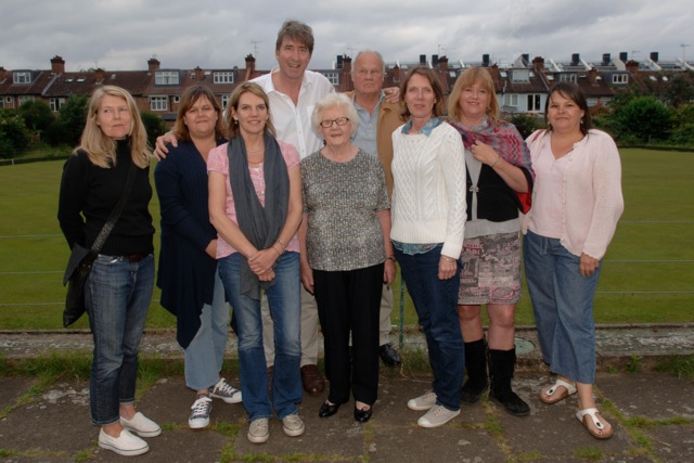
The newly elected WLBC committee

The newly elected WLBC committee

The clubhouse has been refurbished and repainted, and much volunteer effort has gone into cleaning up the building and finding new furniture.

A new website has been set up at this link and you can contact the Club at Chair@westlondonbowlingclub.com.   There will be evening events at the Club, with lots of ideas coming forward for how best to provide food and drink in the future (the Club is not currently licensed, but members can bring their own).

Within a few months, the idea of the Club becoming a hub of social activity in this area is being turned into reality.  Thanks to a lot of hard work by its committee members, old and new.  Call in at weekends if you would like join, or learn more about bowling..

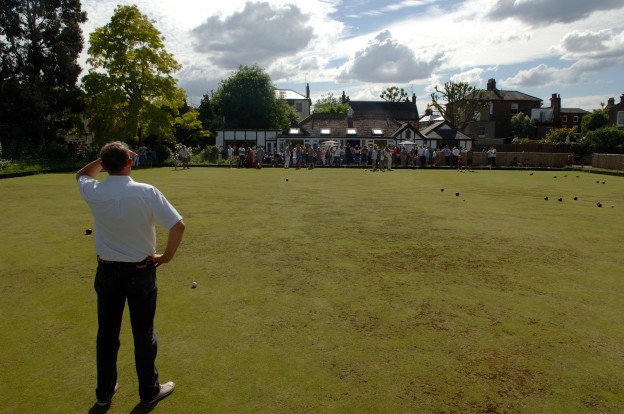
The bowling green and clubhouse

The bowling green and clubhouse


Traffic lights at North Pole Road junction with Wood Lane

The queues and delays at these lights have been a longstanding topic of local conversation, and one raised at several of our public meetings.  The worsening problems are variously attributed to a) the opening of Westfield b) too much traffic on Scrubs Lane/Wood Lane and c) poor phasing of the traffic lights, allowing too few vehicles to make a left turn onto Wood Lane.

The StQW Neighbouirhood Forum has been pursuing the issue with Transport for London. It is this body, rather than either LBHF or RBKC, who control these lights.  Wood Lane/Scrubs Lane is a major through route (the A219).

We have received a detailed reply in response to requests that the phasing of the lights be checked.  This is copied below.  I have also met on site with one of Transport for London’s traffic engineers, at 8.30 in the morning.

On that particular morning the traffic was light and there were no queues.  Just as when one takes one’s car into the garage and it refuses to exhibit the symptoms that led to you to take it there.  Sods Law.

I explained to TfL’s engineer that many of the worst queues occur in the mid afternoon and early evening, as well as during the morning rush hour.  Corroboration was provided by our local butchers, who regularly watch the Barlby Road/St Quintin Avenue triangle become grid-locked and traffic taking 20 minutes or more to get through the lights,.

Transport for London have promised to

  • send out another engineer to observe from mid afternoon
  • recheck the phasing (reviewed and adjusted last year)
  • assess whether the queues in Wood Lane are the real problem, allowing very few vehicles to exit North pole Road when the lights are green
  • check on the number of reports of long delays sent in by bus drivers

TfL also point out that it is LBHF who are responsible for the physical design of the junction.  TfL deal with the sequencing of the lights.

The StQW Forum will be following up on these issues, and including in the neighbourhood plan any possible measures to of improve the traffic flow at this junction.  But the basic problem remains that too much development is being built on the LBHF side of the boundary with no plans to do anything radical in terms of road or rail improvements. Hence our local campaign for a new Overground station beneath the Westway elevated roundabout.

The letter from TfL is as follows.   If anyone wants to see the November 2012 traffic survey data, referred to in the letter, please email info@stqw.org

Dear Mr Peterson,

Thank you for your email and bringing your concerns to our attention

The junction of Wood Lane, Scrubs Lane and North Pole Road operates using a system called SCOOT, which uses sensors embedded in the road surface to detect traffic and automatically adjust signal timings according to the relative demands on each approach.  Resurfacing works earlier in the year had damaged the detectors, which meant the junction was not able to optimise and respond to the demands of traffic as it should.  This may have been the source of some of the difficulties recently experienced.  The detection has now been fixed, so the timings should be back to normal and we can now keep a close eye on the operation and accurately observe the issues you have described.

I will be visiting the site next week, now that the Easter holidays are finished, to watch the junction and see the problem for myself.  I do appreciate the concerns of the residents and we will take time to investigate.  If we can make any improvements or we feel that the balance between north-south movements and east-west movements is not correct, we will investigate what changes can be made.

If you think it would be useful I would be happy to meet you at the junction to discuss the issues.  Let me know if this interests you and we can make arrangements.

In the meantime, here follows an explanation of the way the junction operates now.

The junction operates in four stages:


Northbound Northbound RT Southbound Westbound RT Westbound LT
42s 16s 20s 10s 21s 

Stage 2 is only triggered when northbound vehicles are detected waiting to turn right.  When Stage 2 is triggered the left turn from North Pole Road gets extra green time, which is why green time for this movement is intermittently shorter or longer.  Stage 2 is typically called on around 70% of opportunities between 7am to 10am.  If vehicles turn between gaps in the southbound traffic then Stage 2 isn’t triggered. 

The pedestrian movements occur in stage 4.  When no one presses the button for green man, the extra green time is given to the north-south stage.  During the period 7am to 10am the pedestrian stage runs on approximately 40% of opportunities.  When the pedestrian stage is called, the necessary safety period between the end of green man to the start of north-south traffic green is 16 seconds long, during which time no traffic or pedestrians are given a green signal.  Although it may appear to the driver that this is wasted time, it is the necessary period to ensure no conflict between vehicles and people.

As mentioned before, the junction timings constantly optimise according to the demands of traffic from all approaches.  This means that I can’t quote fixed green times, but the table below gives typical green times for the AM peak hour between 8am and 9am.  Actual green times will differ considerably minute by minute as the junction optimises and when stages are not called by the right turn and pedestrians.


Northbound Northbound RT Southbound Westbound RT Westbound LT
42s 16s 20s 10s 21s

At the bottom of your email in point b you ask for traffic survey data which I have attached.  The most recent data we have dates from November 2012.  We don’t have any delay survey information for the junction.

Comparing crude, automatically collected flows for 2012 and 2013, there was a 2.3% increase in traffic flow at the junction.  This echoes a general trend of increased traffic levels across London over the last year.

In response to point c in your email, TfL have no proposals for a scheme that would reduce traffic levels that use this junction now or in the future.  As for mitigation, TfL will be assessing the impacts of the developments mentioned and will make decisions on what needs mitigating and how based on these predictions.

Please also bear in mind that, whilst TfL manages the traffic signals on Wood Lane, the decision to modify the physical design is the responsibility of LBH&F as this is a Borough-controlled road.


Nursery Lane site up for sale

This piece of land is the latest planning challenge to be faced by the association and the St Quintin and Woodlands Neighbourhood Forum.

This site (behind the houses on Brewster Gardens, the northern part of Highlever Road, and Dalgarno Gardens) has been in use by Clifton Nurseries since 1964.  This company, who are the tenants and not the owners, use it as a plant nursery and storage area for their main outlet in Maida Vale, which is one of very few garden centres in Central London.

The site is one of a number of ‘backland’ sites created as part of the original design of the St Quintin Estate, as an integral part of the original design of this neighbourhood.  Use by Clifton Nurseries has meant that the site, with its many large and mature trees, has been left largely undisturbed since the 1970s when RBKC built sheltered housing on the southern part of the original 2 acres of land.

Now the site has been put up for sale by the owners of the freehold (the Legard family, descendants of the St Quintins).  It is being marketed by .estate agents Knight Frank, with a brochure that says ‘we feel that the site my be suitable for private housing’.

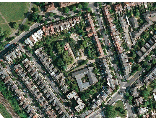
Clifton aerial

This Clifton Nurseries flyer brochure describes the site as ‘an exceptional residential development opportunity comprising just over an acre of land in North Kensington’. The freehold is being offered through an informal tender process, and the sellers will consider either unconditional or ‘subject to planning’ offers.

We have been trying to contact the Legard family for some months, to ask about their long term plans for this piece of land.  Now we have the answer.

Potential bidders are being told that they must make their own enquiries of the council, as to the planning position on the site.  This is a piece of private open land, and the council has a Core Strategy policy (C5) to protect open space, either private or public.  The Oxford Gardens Conservation Ares Statement has a specific policy that these backland sites, created for the local community as part of the St Quintin Estate, should not be used for Housing.

Before the war, most of these sites were used as sports or recreation areas, run by local clubs and societies.  This site was the home of the Ashfield Tennis Club, until a bomb destroyed the tennis courts during the 2nd World War.  It was then used for allotments and for playing fields for Latymer School.

The St Quintin and Woodlands Neighbourhood Plan is likely to designate this and the other remaining undeveloped backland areas as Local Green Space, i.e. very largely open space areas with scope for recreational and leisure activities, as well as providing visual amenity to the neighbourhood.  This would allow for e.g. a tennis or sports club, allotments, and for the re-location of the RBKC community kitchen garden currently in St Quintin Avenue.

The StQW Forum is now consulting with local residents in the streets around the site and in the wider area, on what we as a community would like to see happen on the site.  The StQW Neighbourhood Plan gives us scope to define the planning context for the site, provided that this is in ‘general conformity’ with the council’s Core Strategy.  ‘Local Green Space’ is a new designation, introduced as part of the National Planning Policy Framework, to protect areas such as this.

There is also the option for the Forum applying to add this site to the RBKC Register.of Community Assets (as has already been done with the West London Bowling Club). If such an application were approved, this would trigger a six month moratorium on a sale, while other options were explored.

The next open meeting of the Forum will be on Thursday May 29th 2014 at 8pm at St Helens Church Hall.  Please join us to discuss this site and other parts of the draft Neighbourhood Plan.


Westway advertising towers – local residents have been patient enough

Back in 2009, residents were puzzled to see a new construction emerge on the skyline, at the Westway Sports Centre.  Was it part of a film set, or a sports project?  Surely it was only temporary?

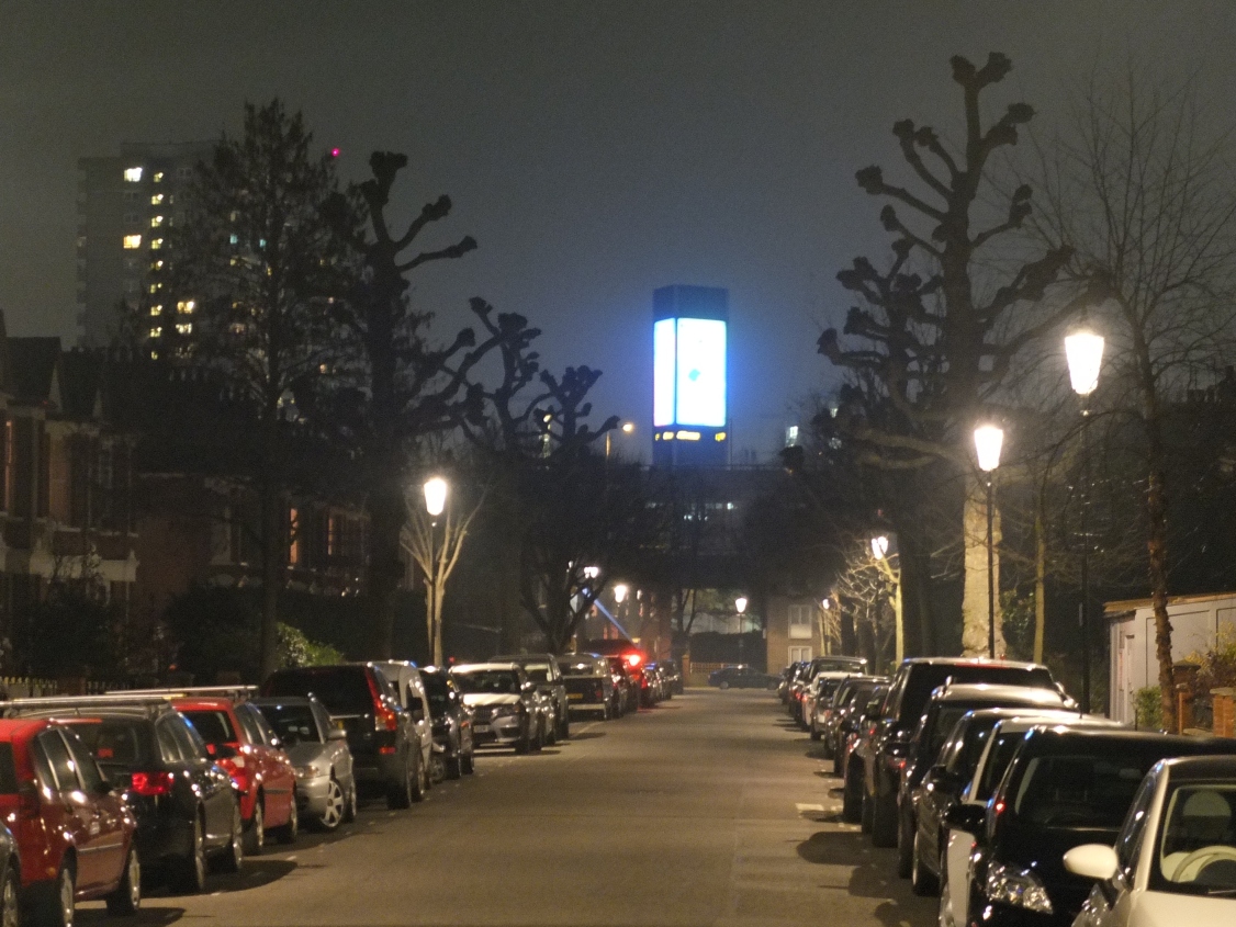
It turned out to be the first of two advertising towers, aimed at motorists on Westway and rising 100 feet into the air.  Illuminated adverts 25 feet high swiftly appeared, and have been with us ever since.   At night they dominate the southern skyline for the full length of Highlever Road and light up the bedrooms of houses and flats on Oxford Gardens.

DSCF1567 reduced

Swiftly nicknamed the ‘Towers of Terror’ a local campaign got underway to get lobby for these adverts to be removed.  It emerged that the Westway Development Trust had leased small plots of land to JC Decaux, the outdoor advertising company.

It also emerged that Kensington & Chelsea had refused planning permission, but this decision had been overturned by the Planning Inspectorate (based in Bristol).  While it seemed extraordinary that a Planning Inspector had approved such a structure on the edge of a conservation area, the decision was made and nothing could be done.

Only a handful of residents in Oxford Gardens had received any notification of the original planning application, or the appeal.  And such notifications that were sent out by the council made no mention of the height and scale of these structures.  Hence only a couple of objections were submitted.  Most residents had no idea of what was coming.

Westway Development Trust chief executive Martyn Freeman was memorably confronted by a mother, at a packed meeting at St Helens Church Hall, who asked how he would like it if his young daughters went to bed and awoke to the sight of an illuminated David Beckham, 25 feet high and in his underpants, gazing into their bedroom.

Martyn Freeman’s explanation that the Trust needed the income from advertising to support its activities did not convince.   We have never been told what sums are involved, despite repeated requests.   And the Trust is a charitable body, managing public amenity land for the benefit of Londoners.  It does not have the excuse that it is a commercial landlord.

After a long campaign by the Association, the council gave written undertakings that ‘discontinuance action’ would be taken on the advertisements, once their initial five year approval had expired.   This felt a long time to wait, but gave some prospect of relief from this blight on the neighbourhood.

The five years expired in May 2013.  Since then, the Association has regularly reminded the council of its commitment to halt the display of the adverts.  We have been given various reasons why such a decision will take time to make, and are now told that the matter will be decided by the council’s Planning Applications Committee, some time after the May 2014 local elections.  This will make it 6 years of waiting.

We have asked to make an input to the committee report, and the material we have sent is at this link WESTWAY ADVERTISING TOWERS – input from SHRA to PAC report.final. We will keep local residents informed of the date of the committee discussion, which will not be before June, and hope to see plenty of you there for the occasion.


Future plans for Notting Hill Gate

Notting Hill Gate is important to us residents of St Helens, as a place to shop, see a film, or have a meal.   Many people living in these streets were drawn towards this area because of its relative proximity to Notting Hill Gate, which has always been seen as an interesting, creative, and slightly bohemian part of London (long before Hugh Grant and the film gave it global recognition).

RB Kensington and Chelsea has been consulting recently on a planning framework for the Gate.  The area was comprehensively redeveloped in the 1950s, as part of a road widening scheme by the London County Council.  Some of its office buildings date back from that period, and others from the 1960s and 1970s.   Most are now outdated.

Several landowners have property holdings in the area, and have been putting together redevelopment proposals.  The largest of these is for Newcombe House (the tall block above Waterstones) and includes the row of shops and restaurants on the west side of Kensington Church Street.

The council’s new draft Supplementary Planning Document for Notting Hill attempts to set some parameters for redevelopment, in terms of building heights and densities.  It also contains proposals for upgrading pavements, public areas, and the entrances to the Underground.

The council’s ‘vision’ for Notting Hill is to retain its role as a ‘district centre’ for shopping and offices, and to improve the public realm for all those who use this very busy public transport hub – including the many tourists en route to Portobello Road.

In recent months the Kensington Society has been working with resident and amenity groups in the area (including St Helens) to refine some of the council’s initial proposals. In particular, the Society has argued that one of the RBKC ideas – that of using £8m of ‘planning gain’ to provide a 2,000 sq.m space for a museum or ‘cultural hub’ was not attracting much local support.  The Design Museum is already relocating to the former Commonwealth Centre in Kensington High Street, and does the borough need another museum space which might turn into an expensive ‘white elephant’.

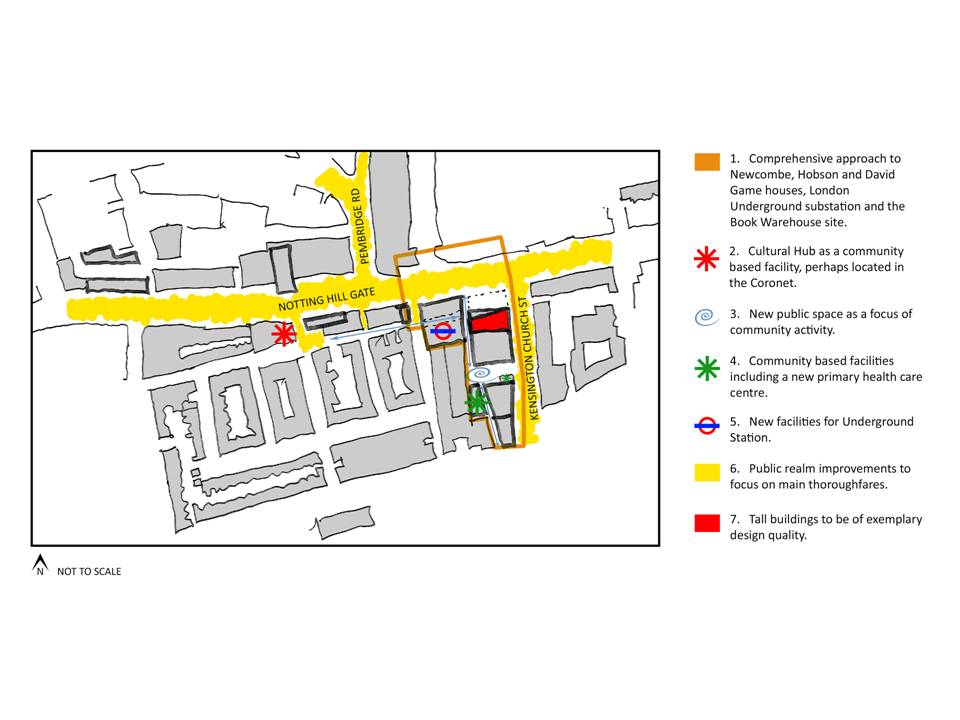
The Kensington Society view, which has been widely supported, is that this £8m of public funds could be better spent, and could in part be used to secure a new public square, within the redevelopment of Newcombe House.  This is seen as giving the area a much needed focus, sheltered from the windswept main road, and an attractive locatiion for shops, cafes and resturants (as well as the Farmers Market).  The redevelopment of Duke of York Square, off the Kings Road, is cited as an example of creating successful open space within a new retail development..

The Society’s proposals are shown in the diagram below:

NHG

An issue likely to prove contentious once planning applications are submitted is the height of redeveloped buildings.  Developers will be looking to build high, in order to maximise profitable floorspace.  The owners of Campden Hill Towers would like to adds another couple of storeys.  The developers of Newcombe House has shown plans which include and office and residential tower half as tall again as the present building.  The council generally has strict policies on tall buildings, but will allow them in district centres maximise where they are claimed to provide a ‘landmark’ building of high architectural quality,  Residents of Hillgate Village wait to be convinced.

Having listened to the views of the Kensington Society and other groups, the council has shown some willingness to modify its original plans.  It will not be publishing the final version of the Noting Hill SPD until after the May elections, and may consult further before doling so.


height in order

Planning application to relocate Chepstow House School to 49 Bassett Road

This proposal from the Alpha Plus Group of schools has been around for a year or so. A previous planning application was turned down by RBKC.  A revised application was submitted a couple of months ago.

We asked all our membership for a view on this controversial planning application to relocate Chepstow House School to Bassett Road.
 
The outcome, from the 66 of you who responded, was as below:
Supporting the application    12
Opposing the application      41
No view either way                13
The main concerns raised were in relation to traffic, parking, and the road safety issues on the junction at the mini-roundabout on St Marks Road/Bassett Road.  Along with potential noise nuisance for those in neighbouring houses and the fact that the building at 49 Bassett Road is too small for a school of the size proposed.
On the basis of this response, the association sent in a letter of objection to the planning application.  The main concerns, as with the earlier application, were in relation to traffic problems, road safety at the junction and mini-roundabout, and potential noise nuisance to neighbours.
Our letter can be seen here SHRA_to_RBKC_objection_letter_Oct_2013
We understand that letters of support and objection (of which many hundreds have been sent into the council) have been in roughly the same ratio as your votes.  The council’s Planning Applications Committee will make the final decision on the application, in the next few weeks.
 

White City planning framework finalised – but how little has changed…

Hammersmith & Fulham Council on October 23rd will be adopting the final version of the White City Opportunity Area Planning Framework.

This will become a Supplementary Planning Document to the borough’s Core Strategy, and will be taken into account when decisions are made on planning applications for sites in the Opportunity Area.

The document has been through two rounds of public consultation, one in early 2011 and one in mid 2013.  In the long interval between the two, the council granted planning permissions to developments on most of the key sites in the Opportunity Area.

These included the Imperial West scheme (with its 35 storey tower), the Helical Bar scheme (32 storey tower) and the next phase of Westfield (20 storey tower).

In response to both consultation exercises, local people said they did not want to see very tall towers in this part of London.  The idea that it was somehow ‘appropriate’ to build a cluster of very tall buildings alongside Westway, as a ‘gateway to London’, has been widely derided and received no support in the consultation responses sent in the council.

Has the council taken any notice, in finalising the planning framework due to be approved next week?

If you read the Summary of Consultation Responses (on the council agenda) you might think the council would be making changes to final version of the planning frameworkl.  Council officers summarise the consultation responses as saying: 

The overwhelming concern expressed relates to guidance in theWCOAPF regarding building heights. Whilst there is some support for more flexibility regarding where tall buildings can be located in the opportunity area the majority oppose the building heights as being excessive and express concern regarding their impact on surrounding areas especially the impact on conservation areas.

Of most concern are the two towers proposed in the indicative masterplan on either side of the Westway and their detrimental effect on the skyline and their impact on local residents to the north and east including residents in RBKC and the Stable Way traveller’s site.

If you read what has actually changed in the text of the OAPF, as a result of this response from the public, you will see that the answer is very little.  Below is one of two textual edits to this part of the final document:

Slender towers of approximately 21-30 storeys (up to 100 metres) would be appropriate along the Westway has been changed to read Slender towers of approximately 21-30 storeys (up to 100 metres) could be appropriate along the Westway.

As before the document blithely ignores the fact that the council has already approved two schemes with 35 and 32 storey towers in this location.  Why has the wording not been amended to reflect current reality (as it has elsewhere in the document?)

Answer – because the council knows that buildings of this height have stretched national and London Plan policies beyond their legitimate limits, and they do not wish to acknowledge this in what will become part of the Borough’s statutory planning framework.

The only other textual change to this part of the document is as below:

The indicative masterplan identifies the limited locations where taller buildings might be suitable has been changed to read The indicative masterplan identifies the limited locations where taller buildings would be suitable

Note that this change has been made as the final outcome of a two-stage consultation exercise in which the responses from the public have said the complete opposite to the thrust of this revision.

So that is it.  A long-drawn out process of public consultation on a strategic planning document, spread over several years and costing large sums of public money, and these are the end results?

This is why the general public has lost faith in the planning system, and in consultation processes that are required by Parliament but which can be rendered meaningless in practice by a council that wants to get its way.

The council made up its mind several years ago, in close dialogue with developers, about building heights in White City East.  It has refused to listen ever since.  

The one hope now is that Imperial College may prove a better listener.  The College has acquired the former Dairy Crest site on Wood Lane, so the prospect of the Helical Bar scheme being built on this site is now past history.

The College has appointed the international firm of Skidmore Owings Merrill to prepare a new masterplan for what is now a combined 22 acre site.   There is the prospect of a much more coherent plan, with better buildings, emerging to replace the currently approved schemes.

The College has shown a recent willingness to talk to the Hammersmith Society, the St Helens Residents Association, and the new St Quintin & Woodlands Neighbourhood Forum, at an early stage in this new masterplanning exercise.

A revised set of proposals could create a university, health, and science innovation complex of world class renown, and one that sits well alongside its residential neighbours.

But this will need the council to join with the College in showing greater respect to the voices of local people.



Neighbourhood plan gets underway

Kensington and Chelsea Council has now formally ‘designated’ the new St Quintin and Woodlands Neighbourhood Forum.  The background documents can be seen here on the council’s website.

An inaugural meeting of the Forum was held at St Helens Church hall on June 27th 2013.  A constitution was adopted and a 10 person management committee elected. There remain 4 places on the management committee and others have come forward since the meeting to express interest in joining the committee.  There will be further decisions on membership at the next open meeting (scheduled for September 12th).

More details about the forum and the neighbourhood plan are on the new website at www.stqw.org

In future, the new website is where information about the plan will be published and comments can be left.

The St Helens Residents Association will continue as a separate body, and will have less need to get involved in the detail of planning issues. Existing members of the association are also deemed to be members of the forum, and will be notified of meetings and consultation sessions.

St Helens Festival 2013

The association had a stall at the very successful St Helens Festival on July 6th.  A total of 28 new members signed up to join, bringing our total membership to over 300.  This helps to strengthen the voice of the association (and the new neighbourhood forum) on decisions that affect the area.  Whether it is on the major plans for developments in this part of London (including the long-term plans for the HS2 transport interchange at Old Oak) or the future of health services in our immediate neighbourhood, there is a lot happening at the moment.

Designation of this area for a neighbourhood plan means that detailed work can begin on putting the plan together.  This will include a look back at the history of the area, an update of conservation policies, and ideas for ensuring the long term success of the shopping parades and regenerating Latimer Road.

We need to gather together everyone’s views on what is good about the area, and what may be threats or unwelcome trends for the future.  Please use www.stwq.org or the comments box on this site to feed in your suggestions.


Neighbourhood forum to be launched at end of June

After a long wait, designation by Kensington & Chelsea council of the proposed St intin and Woodlands neighbourhood forum is now imminent.  An inaugural meeting of the forum has been convened for Thursday June 27th, at 19.30 pm at St Helens Church hall.

leaflet inviting all who live or work in the plan area to come to the meeting (and/or to join the forum) is being circulated to the 1,500 or so households and businesses in this neighbourhood (see map below).

At this stage, it is the larger part of the area within RB Kensington & Chelsea that is being formally designated for neighbourhood planning purposes.  Hammersmith and Fulham Council has yet to reach a decision on the part within its borough.  We hope that the council will ultimately decide the designate this part also.

In meantime, membership of the forum is open to anyone living or working in the plan area.  There is no charge for membership.  St Helens Residents Association has been awarded a grant of £6,760 from the Government, to enable the forum to meet the basic costs of preparing a neighbourhood plan (consultation materials, meeting room hire etc).

A new website for the forum has been set up at www.stqw.org.  This includes background information and an online membership form.  Existing members of the St Helens Residents Association will be deemed to be members of the forum without having to fill out this form.  But if you know of other neighbours who would be interested, please encourage them to use the new website and online form to communicate their contact details.

In future, news and documents relating to the neighbourhood forum and plan will appear on www.stqw.org rather than on this website.  St Helens Residents Association will continue as a separate body, working to improve the overall quality of life in the area.  We hope that with the neighbourhood forum taking on the longer-term planning issues, that SHRA will have more time and capacity to look at other concerns such as health services, policing and community safety in the area.


Preparation of Neighbourhood Plan to start soon

After a long wait, formal approval is expected shortly for the start of preparation of a Neighbourhood Plan for this area.  RB Kensington and Chelsea are due in May to ‘designate’ their part of the proposed St Quintin and Woodlands area.  For a map and more details of these proposals see at this link.

The delay on these proposals has not been the fault of RBKC.  The proposed plan area extends westwards to Wood Lane, in order to include the triangle of housing around Eynham Road and the Imperial West site.  Following a 6 week consultation exercise last summer (when views for and against the proposals were evenly balanced) LB Hammersmith & Fulham has since chosen not to reach a decision on whether to designate that part of the plan area in their borough.

So the way forward will be for RBKC to grant approval for the larger part of the plan area (see map below). The process of consulting locally and drawing up a draft plan can then get underway.  In the next few weeks we will be circulating all 1400 households, businesses and shops in the plan area with basic information explaining the process.


We will be looking for people who are interested in coming together on the management committee of what will be a newly constituted body – the Neighbourhood Forum for this area.

We hope that residents and businesses on the LBHF side of the boundary will want to take part in local discussions, and that Hammersmith & Fulham Council will eventually be persuaded to designate their part of the area.  In the meantime, the arrangements for the Forum and Plan insofar as they relate to LBHF will be in ‘shadow’ form only.

The Government has started a new programme of funding for neighbourhood plans.  Over 300 neighbourhoods across England are currently taking the opportunity to prepare such plans.   Grants of £7,000 will be available to neighbourhood forums, to meet the costs of holding consultation sessions, and putting together a draft plan.  We intend to apply for such a grant when bidding opens on May 1st, so that the new Forum has some resources to progress the necessary work.

Membership of the new Forum will be open to anyone living or working in the area. If you are interested in knowing more, or taking an active role in the management committee of this new body, please email to sthelenassn@aol.com.